Historic Events

WWII Photos of Portsdown

Created 21-07-2002    Last update 11-04-2006

click the arrow

<

page 1 of 5

>


Below are a set of photos taken on or near Portsdown during WWII. The southern side of Portsdown includes the following districts: 

Districts of the southern side of Portsdown

District Condition - WWII Condition - 2002
Cosham Village Fully developed - shopping precinct
Drayton Private housing development Private housing development
Farlington Private housing development Private housing development
Paulsgrove Fields Fully developed housing estate
Portchester Village Fully developed - shopping precinct
Wymering Partly built council estate Fully developed housing estate


gask mask drill - Clacton Pub - 1940

1940. Gas mask practice outside the Clacton Pub - now demolished - Clacton Road Wymering. The arrow at centre top points to my Mum, then aged 12, the top right arrow to my Grandfather - Bert Coleman.  


Cosham Home Guard

The Cosham Home Guard, in serious mood, get some rifle practice in.


Cosham Home Guard get some kit

The availability of kit was always a problem for the Home Guard. Here the Cosham Home Guard at least have a pair of new boots.


first aid post at Cosham

An exercise at the Cosham First Aid Post.


Second Avenue 1941Second Avenue 2002

1941

2002

On 11 April1941, a Landmine (as it was termed in those days)  almost took out an entire road at Second Avenue and Hardy Road, Farlington. It is possible to make out the replacement buildings today.


House wrecked by a Landmine

Another shot of the Landmine damage at Farlington, 11th April 1941. A Landmine was a modified Seamine dropped by parachute. Due to successful British mine counter-measures the Germans had considerable stock of obsolete Seamines which they disposed of in this way.


Although I wasn't there the night of the parachute mine, 
the family story told endlessly during my childhood was that the 
blast blew in all the front windows and the front door & frame was 
half up the stairs, the gable end of the house was cracked & bowed & was rebuilt by the War Damage Commission after the war. I recall the empty space in 2nd Ave for many years after the war.

Malcolm Ainslie - March 2006


NEW 11-04-2006

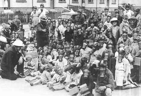
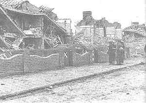
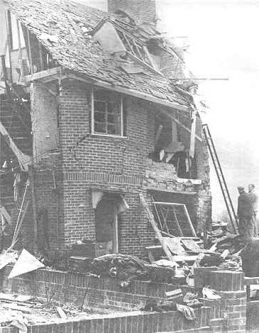
I was very interested with the photos of the damage done by the landmine that dropped on Second Avenue Farlington. I lived in Second Avenue and was 8 years old at the time the mine dropped. Second Avenue was in two parts one end was adopted and one end was not, this resulted in one end being tarmac road with pavements and the other end had nothing done to it at all. I lived in a house close to the end with St Andrews Rd. When it rained in front of our house it was like a huge lake. We lived at the rough end of the road but it was the tarmac end that got the mine [very nicely put!].

At the time we had 16 people living in our house most of which had come out of town and thought it was safer. I remember my uncle built a temporary cooking range at the back of the house to try and satisfy everyone living there. After the landmine dropped and all our windows were blown out all the visitors from the town soon left and we were back to just my mum and dad and my brother. 

On the morning after the mine had dropped I remember going to have a look and remember seeing this huge crater in the middle of the road and where the houses were completely demolished only the brick shelters remained standing. When you had a brick shelter you had to supply your own door and all the doors had been blown off. Also in the back of each shelter was an escape hole which consisted of about two feet square of brickwork which was laid with just sand courses and these also had been blown out. 

Although as kids we were not supposed to be anywhere near were the landmine dropped they couldn't keep us away and proof that we had been there was to come away with some of the silk rope from the parachute which was attached to the mine.

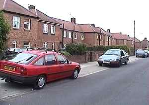
Since being married I have lived in the Drayton area for nearly forty five years and I often walk through Second Ave and look at the house I lived in at the time.

Brian Ward - April 2006


Portsbridge roadblock

NEW

Portsbridge which links the island of Portsmouth to the mainland is here guarded by a roadblock. In the background is Portsdown Hill. The armed guard is provided by the Royal Navy. The primary intention of such a block was anti-invasion but it was also used to control the movement of the civilian population. Fort Purbrook was nominated as a 'holding centre' should an unauthorised evacuation of Portsmouth take place. 


click the arrow

<

page 1 of 5

>