|
|
|
Legends
& Mysteries
Fort
Purbrook - Tunnel No1 |
|
| Created
15-07-2002 Last update 08-08-2003 |
|
|
|
|
click the
arrow |
|
< |
page
2 of
2 |
|
|
|
|
|
|
Crookhorn Redoubt - Tunnel No1
|
|
|
|
|
Crookhorn was to have had
Caponiers,
counterscarp and scarp galleries and its own magazine and barracks. Unfortunately
the fort was sited half on a stratum of blue slipper clay, and in order to
reduce costs the northern half was abandoned leaving the remainder as just
a prepared earthwork. It could have had little value and is shown as
demolished in the armament returns of 1876.
The plans for Crookhorn Redoubt show that
it was to be linked to Fort Purbrook by a tunnel. The Solent Papers No 3
first published 1987 by Gary Mitchell state: there is evidence
for this [a tunnel] in the Musketry Gallery at the end of the double
Caponier at the
north east salient of Fort Purbrook.
|
| |
|
|
|
|
|
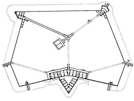
Lower
plan
of Fort Purbrook. 'A'
is the Musketry Gallery in the double Caponier of the north east salient,
where evidence of a tunnel to Crookhorn Redoubt was said to exist. Copyright
David Moore - Palmerston
Forts Society
|
|
|
|
|
|
|
|
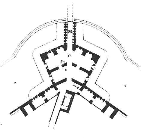
Original
plan
of the northeast Caponier (marked 'C') and the Musketry Gallery
(marked 'M) of Fort Purbrook. Notice the hatched lines leading
away northwards from the Musketry Gallery. Copyright
David Moore - Palmerston
Forts Society
|
|
|
|
|
|
|
|
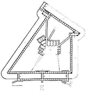
Lower
plan
of Crookhorn Redoubt. On
the bottom left of the plan is the tantalising legend "Tunnel
to Fort Purbrook". Copyright
David Moore - Palmerston
Forts Society
|
|
|
|
|
|
|
On 24 July 2002 as part of a visit to Fort
Purbrook organised by the Palmerston
Forts Society, I made my way to this part of the Fort along with Peter
Cobb from the UK Fortifications
Club. The idea was to see exactly what the 'evidence', as recorded in
the Solent Papers No3, consisted of. We were pretty surprised when we got
there.
|
|
|
|
|
|
|
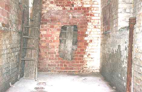
At
the end of the Musketry Gallery of the north east
Double Caponier is a bricked-up section of much later origin
than the surrounding Victorian brickwork. At some time in
the last five years - since the last visit by Peter Cobb - a
hole has been knocked through this revealing some boarding-up
behind it. Interestingly there is no sign of Doorpost or
Lintel - the "blind wall" concept. Was this tunnel walled-up during construction
and only to
be broken down in desperate circumstances?
|
|
|
|
|
|
|
The more modern brickwork was obviously the
'evidence' referred to in the Solent Papers No 3, and is thought to have
been put there sometime during the second world war or later. The brick-laying was done with care, and
has been bonded into what was
the Victorian opening. It was just possible to photograph what was
behind the upper right portion of the boarding-up.
|
|
|
|
|
|
|
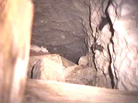
It
was just possible to photograph through a gap in the top right of
the boarding: a tunnel - or at least the roof of one. It is only around
5 feet in
height, and backfilled with chalk to within 9 inches of the roof.
The top of the tunnel is 2 feet 6 inches wide, but increases in
width - maybe up to 3 feet - at the base. It was only possible to
see back 10 feet. The narrowness of this portal suggests that it
was a 'pinch point' allowing it to be defended with comparative
ease. It probably opens out into a larger tunnel a little further
back, along which fully armed troops could move.
|
|
|
|
|
|
|
|
|
|
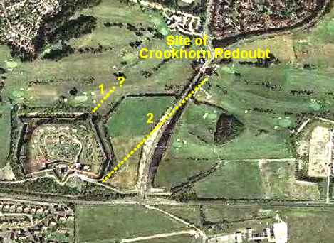
An
aerial photo showing the positions of the two known tunnels
emerging from Fort Purbrook. No 1 tunnel is awaiting further
investigation..
No 2 tunnel is described here. The location of the suspected tunnel to Farlington
Redoubt, located on the right, is still unknown but I suspect that
it tees-off from tunnel No 1. |
|
|
|
|
|
|
Fort Purbrook was
one of the few Forts to be
fitted with Chicanes in the tunnels below the parade ground. One such
equipped tunnel is the one leading to the north east Caponier described
above. [a chicane in this sense is used to describe
a deep pit in the tunnel covered by a drawbridge. If the enemy get into the
Caponier then the drawbridge can be raised leaving both pit and barrier as
a defence]. It could be said that the reason
chicanes were used in this instance was because of the vulnerability that
the Crookhorn / Purbrook tunnel presented. If the enemy took Crookhorn
Redoubt then there was a direct route into Fort Purbrook. The only other
forts that I know of that were fitted with Chicanes because of their vulnerability
were
Grain
Fort and Detached
Bastion Western Heights. One other thing.
It is my belief that if a Fort Purbrook / Farlington Redoubt tunnel exists
then it will be found as a tee junction in the Crookhorn
tunnel. In support of this theory here is an extract from the Illustrated Times
of 26 September 1863. For the term 'sunken gallery' read tunnel:
| At the east end of the hill the works are the least forward of any, but here may be seen the unusually formidable nature of the
trace. It is commanded by three works Farlington, Crookhorn, and Purbrook. All three have yet proceeded in their construction but little beyond their formation of parapet and ditch and general outline. Their height reaches -300ft. above Ordnance level. Farlington commands the eastern point of Portsdown, and will mount eighteen of the heaviest guns on its terre-plein, with mortar-batteries in the angles of its surrounding ditches, each battery mounting three mortars.
A sunken gallery communicates with Crookhorn, which will mount sixteen guns on its terre-plein, with six guns in the angles of its ditch.
A continuation of the same sunken gallery leads from Crookhorn to the main work at this eastern
end of Portsdown -Purbrook which will mount twenty-one guns on its terre-plein, nine guns in caponieres in the ditch, and three mortars in the ditch‘s west angle. It has a nearly straight face of 240ft., looking inland; the open gorge being opposite the west side of Langstone Harbour. The ditches surrounding the three works vary in depth according to their position from 35ft. to 50ft. Sunken galleries from the interior of the works communicate with the mortar batteries and caponieres in the ditches. |
|
It certainly looks as if the legendary tunnel connecting Fort
Purbrook to Crookhorn Redoubt is no longer a legend, but it still remains
a mystery as there are un-answered questions remaining such as: how long
is it? Is there any archaeology in there? Does it continue in the right
direction? In response to this I am currently attempting to get permission
from English Heritage to investigate further.
|
| |
|
***
Latest News ***
On
8 August 2003 I met at the fort: Rob Perrin from English Heritage
and Jenny from Portsmouth Museums and Records Service. We had a
meeting to discuss ideas about how the tunnel could be further
investigated and after inspecting the portal it was suggested by
me that the best thing to do was to remove 1 or 2 bricks in the
wall at tunnel roof level so that a visual inspection could be
made to determine just how extensive the tunnel and the backfill
was. Rob Perrin was very agreeable to this since it meant that
only the post-Victorian brickwork would be disturbed and because
it raised no health and safety concerns. Likewise Jenny thought
this 'minimum use of force' idea made sense and said that
she would contact the relevant departments in Portsmouth City
Council to verify that this course of action would be acceptable
to the forts owners.
During
this last visit I managed to squeeze a camera through the gap
between the wall and the boarding-up and take some photos using
infra-red for illumination. Here are the results: |
|
|
|
|
|
|
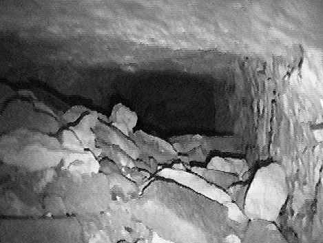
View
above the back-fill. Notice that there seems to be an edge to the
right-hand tunnel wall about 12 feet back from the portal.
|
|
|
|
|
|
|
|
|
|
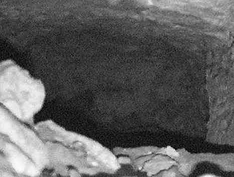
A
close-up shows the edge more clearly.
|
|
|
|
|
|
|
|
|
|
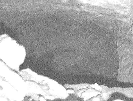
This
enhanced photo of the above shot seems to indicate that the tunnel
takes a right-hand turn. This would correspond exactly to the
layout of the Crookhorn end of the tunnel in the plans above.
Other possibilities are a dead-end (but then why bother
back-filling the entrance?) or water vapour. The back-fill is
casting a shadow indicating that it ends here.
|
|
|
|
|
|
click the
arrow |
|
< |
page
2 of
2 |
|
|
|
|

|


