Pre-1850 Sites

Portsdown Semaphore Telegraph

 Created 23-11-2004   Last update 23-11-2004

click the arrow

<

page 2 of 2


The Semaphore

On 29 June 1815 and act of Parliament was passed enabling the Government to acquire land for the new Semaphore  Telegraph Stations. These were to be a permanent replacement for the Shutter Telegraph described on the previous page

From March 1816 when the Shutter Line was closed until the end of June 1822 when the Semaphore opened, Portsmouth was without a telegraph communication. In most cases the location of the new Semaphore stations were not the same as those of the old Shutter stations.

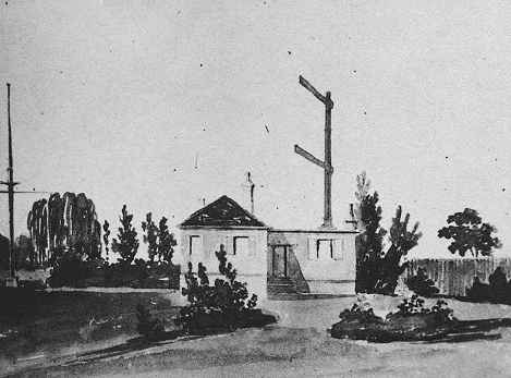
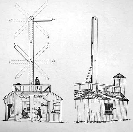
There were various designs submitted for the new Semaphore Telegraph, but the Admiralty chose a design by Rear-Admiral Sir Home Riggs Popham. His idea was to use two signalling arms, instead of the three used by the French, at different heights on a mast 30 feet high. By July 1816 an experimental line had been constructed between the Admiralty and Chatham and was in working order. The Semaphores were made by Messrs Maudslay and the telescopes were supplied by Dollond.

On 19 February 1818 Mr Thomas Goddard, a Purser from the Royal Yacht - Royal George - was instructed to carry out a survey of the route of the old Portsmouth Shutter line with a view to working it with Popham's semaphore. After much delay in acquiring land and with building work, the stations began working at the end of June 1822. The cost of maintaining the stations was £3,000 per annum.

1

Admiralty - London SW1

2 Chelsea - London SW3
3 Putney Heath - London SW15
4 Coombe Warren - Kingston-on-Thames
5 Cooper's Hill - Esher
6 Chatley Heath - Cobham
7 Pewley Hill - Guildford 
8 Bannicle Hill - Goldalming
9 Hastle Hill - Haslemere
10 Holder Hill - Midhurst
11 Beacon Hill - South Harting
12 Compton Down - Compton
13 Camp Down - Portsdown Hill
14 Lumps Fort - Southsea (needed to avoid the smog of Portsmouth)
15 Portsmouth Dockyard - Portsmouth

Portsdown Semaphore Station

The new Semaphore Stations were of far more substantial construction than the Shutter Stations they replaced. There were four different designs to suit the different geographical locations. The one at Portsdown was an ordinary looking country bungalow of five rooms each about 13 feet by 11 feet. The roof was slated and the walls were rendered brick. The Semaphore room was 8 feet by 7 feet 9 inches and sat on top of the building which was unique to this station. The telescopes were located in tubes set in holes cut through the walls. There was no well and all water had to be transported by the station's own water cart for which a horse had to be hired. The station crew consisted of an RN Lieutenant and a Handyman - or Signalman - who was often a retired sailor.

The mechanical Semaphore was finally overtaken by modern technology in 1847 with the coming of the Railways and the Electric Telegraph. Wires were laid alongside the LSWR line into the Royal Clarence Yard at Gosport and then by submarine cable under Portsmouth Harbour to HM Dockyard Portsmouth. On the 13 September 1847 the stations' crews received their redundancy notices and were finally stood down on 31 December 1847.


Grid Ref SU688064 - Portsdown Station


1870 map Camp Down

An 1870 map showing the location of "Semaphore House" on Camp Down. In fact by 1870 the station had been demolished and the roadway moved 208 yards south to accommodate the construction of the Palmerston Forts in the 1860s. The forts never appeared on these early maps for reasons of national security, in fact some never appeared until 100 years later.   


2004 map Camp Down

A 2004 map, the 'X' showing the location of the Semaphore station. Notice that the roadway (B2177) has moved south something which caused me some confusion whilst researching this subject. The position for the  above plot was obtained by transferring the 12 figure grid ref  (468875,106412) from the 1870 map. The course of the original roadway, which was Pre-historic/Roman, exactly follows the west/east fence line above the 'X'. It was moved south because Farlington Redoubt on the left would have sat bang on top of it.


 Aerial photo of site

 An aerial photo showing the location of the Semaphore Station (X). The course of the original roadway is clearly defined as the boundary between the two different coloured fields. The polygonal scar is what's left of Farlington Redoubt. The ROC is known to have used this area in WWII, and the tiny mark in the field just above and right of the 'X' is possibly the base of a Nissen Hut, there are two others to the east of it out of shot. Camp Down is also reputed to have been the training ground of many of England's Archers and is the site of Bevis Long Barrow


2004 site of Semaphore

 Camp Down (2004) looking east towards Belmont Castle (now a rest home and not a castle at all) on the middle left. The Semaphore Station would have been in the mid-ground where the darker patch is. One acre of land was allocated to the station for vegetable growing, chickens etc. and it was surrounded by a hedge and later a railed fence. The original roadway ran where the fence is on the left.


Putney Station

 The photo above shows the Putney station which was of similar design to the Portsdown Semaphore Station of which no photographs appear to exist.  However the Portsdown station had an extra floor where the semaphore mast is shown with the mast on top of this. Portsdown was also the only station not to have a cellar though this is contradicted in some documents.


Semaphore Mast

 A representation of the the Semaphore stations used on the Portsmouth Line. The masts were 30 feet high with two arms 8 feet long and 1 foot 4 inches wide. When at rest the arms folded inside the mast.


click the arrow

<

page 2 of 2